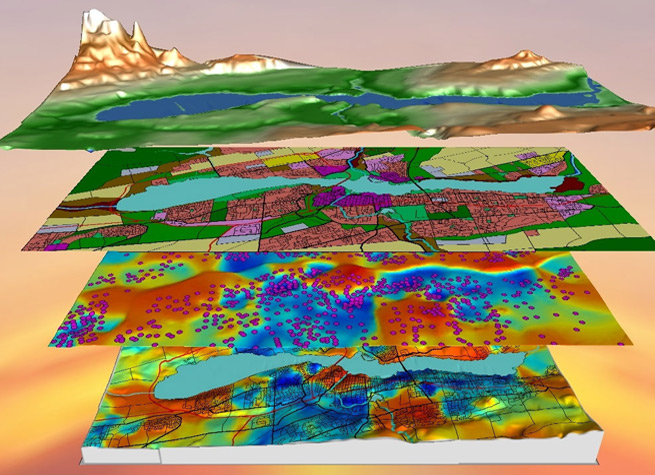

Geospatial Services
McCord Engineering’s Geospatial Services team is always seeking new and more cost-effective ways to bring valuable data from the field to the office in order to meet all of your data collection, data processing, and GIS needs. We tailor every data collection mission to meet the specific business needs of our clients. Then we deliver the data in a format designed to integrate seamlessly into each client’s engineering or decision-making workflow.
Data Collection Services:
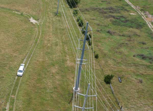
Unmanned Aerial Vehicles (UAV)
Using a UAV platform for data collection sensors and high-resolution cameras provides a vantage point for the most complete information and imagery available. Another major benefit is that UAV data collection is not subject to the same access limitations as ground-based data collection. Data that once took days to obtain through traditional survey and inventory methods can be gathered in a matter of hours – with greater accuracy and far more detail!
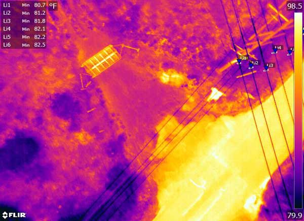
UAV Sensors
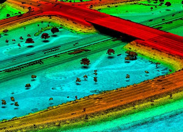
- LiDAR
- FLIR Infrared
- 4K Video High Resolution Still Cameras
- Normalized Difference Vegetation Index (NDVI)
In most cases, all sensors can collect data simultaneously in one flight. This creates a series of data that can be used for many different applications. For more information on unmanned aerial vehicles click here.
LiDAR Data Collection
Our team will determine the best method of data collection to deliver the most accurate product at the lowest cost to our clients.
- Unmanned Aerial Vehicle
- Terrestrial LiDAR
- Stationary LiDAR
Analysis and Design:
PLS-CADD Modeling
From our experience with powerline design and LiDAR, our team of PLS-CADD technicians has developed many different procedures and techniques to produce high-quality products and services for our clients. MEI uses LiDAR data to model existing terrain, structures, conductors and aerial obstacles. These models can be used for:
- Engineering
- Line Clearance Analysis
- Communication Joint Use Audits and/or Permits
- Thermal Rating Analysis
- Vegetation Management
- As-Built Surveys
- NERC Compliance Analysis
ESRI
- App Development
- On-site data storage or cloud based solutions
- Integration with many different GIS and design software
- Data Collection Solutions
Data Integration Solutions
As technology advances, the issue of storing large quantities of data continues to grow. Emerging technologies gather valuable data at incredible speeds, capacities, and variations. MEI’s Geospatial Services team has developed techniques to collect pertinent information from this data and deliver it in a manageable format to our clients. We work closely with our clients to assure the data integrates to each client’s required software.
Asset Management Solutions
Do you need help managing your utilities assets? Are you still relying on labor-intensive paper maps, handwritten forms, Excel spreadsheets and emails? MEI provides a reliable asset management system, complete with customized software that can generate a broad array of data types and implement them directly into your existing workflow. Regardless of the GIS environment, this data can include maintenance plans, vegetation management, and even work order generation, just to name a few. By automating your asset management and letting the data handle itself, you save valuable time and effort.
Research and Development
Our team strives to push the limits of today’s technology by using the latest systems and equipment. We remain in close communication with many of our software vendors to ensure their systems are built and maintained with your interests in mind, while also developing our own utilities in-house to keep our workflow operating efficiently. A dynamic combination of expert-tested, custom-built hardware and industry-leading software advance our methods and practices to constantly keep us ahead of the competition.
For more information about Geospatial Services, contact Rex Woods.
What Our Clients Have to Say…
McCord Engineering started providing work order inspections prior to 1989 and our relationship with McCord Engineering has grown to being our main engineering firm doing two year and long range work plans, sectionalizing studies, designing and inspection of transmission upgrades, and designing distribution work plan projects. We have found McCord Engineering to be very competent and innovative group using the latest technology such as lidar drones to survey and design distribution lines and assist us with any needs.
Clayton Stanford
Engineering Director
San Bernard Electric Co-op
McCord Engineering is one of the most innovative, forward looking, and technologically advanced consultants Mid-South Synergy have had the privilege to work with. We are proud to have them work with us on our Vegetation Management program using LIDAR and multispectral imagery, an approach that has changed the way we do vegetation management and has the potential to change the utility industry as a whole….
Dr. Comfort Manyame
GISP
MidSouth Synergy
McCord has provided Engineering services to the City of Georgetown since 1988. They are reliable, accurate, and responsive to all our needs and willing to go the extra mile in our behalf.
Jimmy L. Sikes
Electric Engineering Manager
Georgetown Utility Systems/Electric Division
McCord Engineering has been a tremendous resource for CoServ Electric since 1996. When we work with McCord, we are collaborating with engineering experts who are extremely knowledgeable, reliable and responsive to our needs and those of our Members. They consistently use cutting-edge technology and innovative practices to provide a quality product that is complete and efficient. Our track record with them is excellent, and they always commit the resources, time and talent to make our relationship a win-win.
Chris Skidmore
Manager of Major Designs and Standards | Engineering Services